Travel Tales from The Hub
Deeper into Bolivia
More Photo Tips | Video Gallery | Photo Gallery | Enewsletter sign-up

By Ken Hubbard
SP 24-70mm Di VC USD G2: 1/250th Sec, f/16, ISO 200 @ 50mm
Click image to view larger
Time to Head Further South, Deeper into Bolivia: It was hard to imagine anything more beautiful or mind bending than the salt flats in Bolivia during rainy season. I just couldn’t believe that there would be other locations in this country that would take my breath away with the same powerful visual force. Well, little did both André and I know that on the final morning in Uyuni, after another spectacular sunrise shoot on the Solar, we’d be heading further south into the country where the sights would continue to amaze and dazzle on an epic scale.
We left the salt flats and headed south on roadway F5, this road would soon go from being nicely paved to simple dirt and them from there, something that is sometimes marked and sometimes it was not. Either way, thankfully we had hired a great guide and driver through Pure Bolivia (http://pure-travelgroup.com/bolivia/) that fully understood what we were looking for on our private photo tour, it made the next 36 hours an incredible experience.
SP 24-70mm Di VC USD G2: 1/320 Sec, f/16, ISO 200 @ 36mm
Click image to view larger
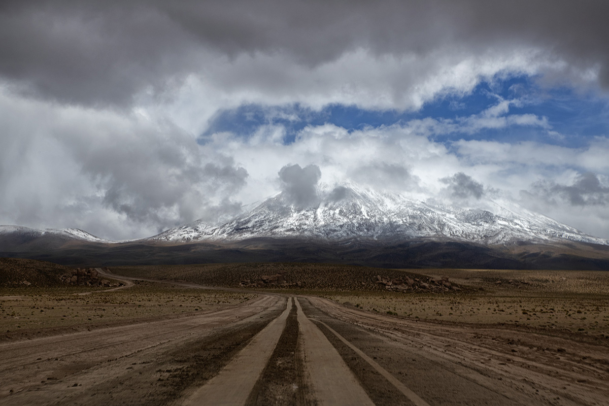
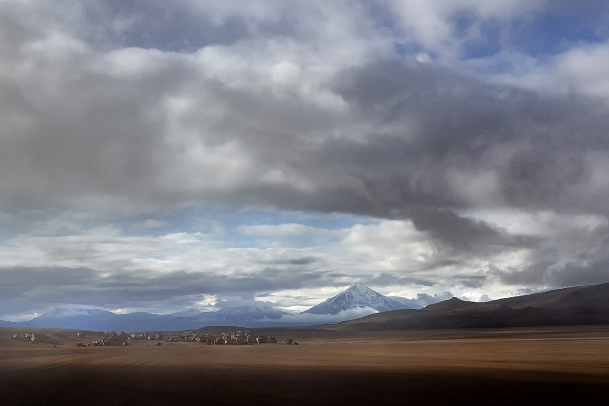
No More Paved Roads: We had left the paved (and for the most part marked) roads behind, so it was time to really get into the heart of Bolivia. This cannot be any more of a true statement (The Heart of Bolivia), because of the geography that makes up this incredible southwest region. As we drove south through an area called Valle De Roccas we got our first glimpse of the true subterranean heartbeat of Bolivia, the first volcanoes came into view. They were sporadic at first dotting the horizon as we drove along the dirt roads, it was sort of like seeing Mount Rainer standing alone, towering above everything in the pacific northwest. The difference in Bolivia is that the further you drive, the more volcanoes you see, and at times they seem to stack up against one another. Mountain peaks turn into multiple volcano peaks all lined up a row.
SP 24-70mm Di VC USD G2: 1/125 Sec, f/16, ISO 200 @ 48mm
Click image to view larger
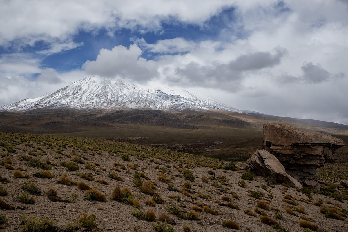
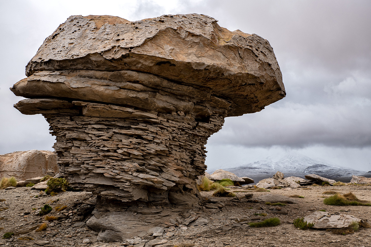
Valle de Rocca: One of the first places we came upon as we drove south out of Uyuni was Valle de Rocca. This 10-mile long valley contains uniquely carved rocks of all shapes and sizes. These fascinating rocks and boulders were created by extensive volcanic activity that molded them into a variety of formations by the wind and rain. Many of the rocks have been named because they resemble everything from animals to inanimate objects. As we made our way along the paths that snaked through the valley, the weather soon started to turn for the worse. Clouds rolled in, and it seemed to add to the mystery of what we were going to come across next.
SP 70-200mm Di VC USD G2: 1/250 Sec, f/6.3, ISO 200 @ 200mm
Click image to view larger
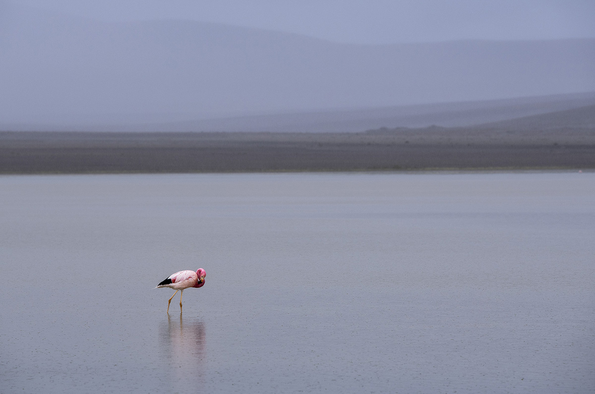
Laguna Campina: After spending time in Valle de Rocca and then a quick stop for lunch the rain began to fall. Slowly intensifying as we made our way to the next destination, Laguna Campina. There are many colorful lakes in Bolivia, unfortunately Laguna Campina is not really one of them. Despite the lack of color in the water, it is known for the very colorful James Flamingoes that flock to the lake to feed on its algae and diatoms. The area is also known for its borax mining. Unfortunately, once this mining had started near the lake it had drastically diminished the number of flamingos that use the lakes resources.
Even though the rain was now coming down pretty steadily, we were very fortunate to have a good number of flamingos close to the shoreline where we were able to capture some images. We were even more fortunate to have an Andean Flamingo standing alone in the shallow water. The grey rainy day made a perfect backdrop helping the flamingo stand out even more in the damp weather because of its beautiful pink and black markings and yellow legs. Currently there are only between 38,000 – 39,000 of these flamingos left in the world, making it one of the rarest.
SP 24-70mm Di VC USD G2: 1/1250th Sec, f/8, ISO 400 @ 70mm
Click image to view larger
28-75mm Di III RXD: 1/200 Sec, f/16, ISO 100 @ 44mm
Click image to view larger
Stone Tree and Laguna Colorada: Now that we were thoroughly soaked and pretty cold from standing in the rain capturing images of pink flamingoes on grey backdrops, it was time to get into the warm truck and head off to our hotel for the night. This is where the road got even more interesting. If you look on a map, there is a line that represents what is supposed to be a road along the shore of the laguna and at the foothills of Cerro Quebrada Honda. It ends up being more of a “sort of, kinda” serious off road 4-wheel drive vehicle recommended way to get from where we were to the lodging we were staying in for the night, Tayka de Desierto (http://desierto.taykahoteles.com/es). At approximately 15,091 feet above sea level, to say it is remote and away from most everything, is an understatement. It is rustic and simple with limited electricity and water consumption. The food was good, and it had warm rooms and beds that were comfortable, which was all we needed after an exhausting non-stop day. On a side note, for those of you who have not been at this type of elevation before, it is highly recommended to bring along elevation meds, they will not only help you get through the day but will also help you sleep well at night.
8 Images with 28-75mm Di III RXD: 1/250 Sec, f/16, ISO 100 @ 75mm
Click image to view larger
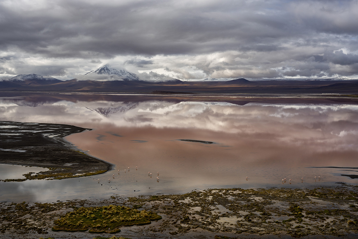
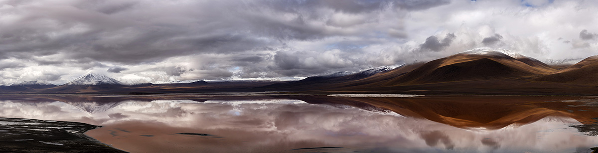
After a great night of sleep, it was an early morning with a full hot breakfast consisting of eggs, meats, cheeses, coffee and a bunch more things I consumed before heading out on our next adventure. Driving along a flat valley in the fog we eventually came upon the entrance to Eduardo Avarona Andean Fauna National Preserve and our first quick stop of the day, Stone tree. This is a random outcropping of giant rocks in the middle of a flat valley that seemed to have just been dumped there randomly, with one of these rocks standing alone looking like a tree. Then it was onto Laguna de Colorada in the high plains region, this brick red hued lake sits at about 14,000 feet above sea level. This high-altitude lake gets its very distinct color from microorganisms and algae that are in the water. Adding to the amazing beauty of this area are some of the rarest flamingos in the world that flock there to feed and the bright white islands made up of borax that dot the lake.
28-75mm Di III RXD: 1/250th Sec, f/22, ISO 100 @ 28mm
Click image to view larger
28-75mm Di III RXD: 1/250 Sec, f/18, ISO 100 @ 28mm
Click image to view larger
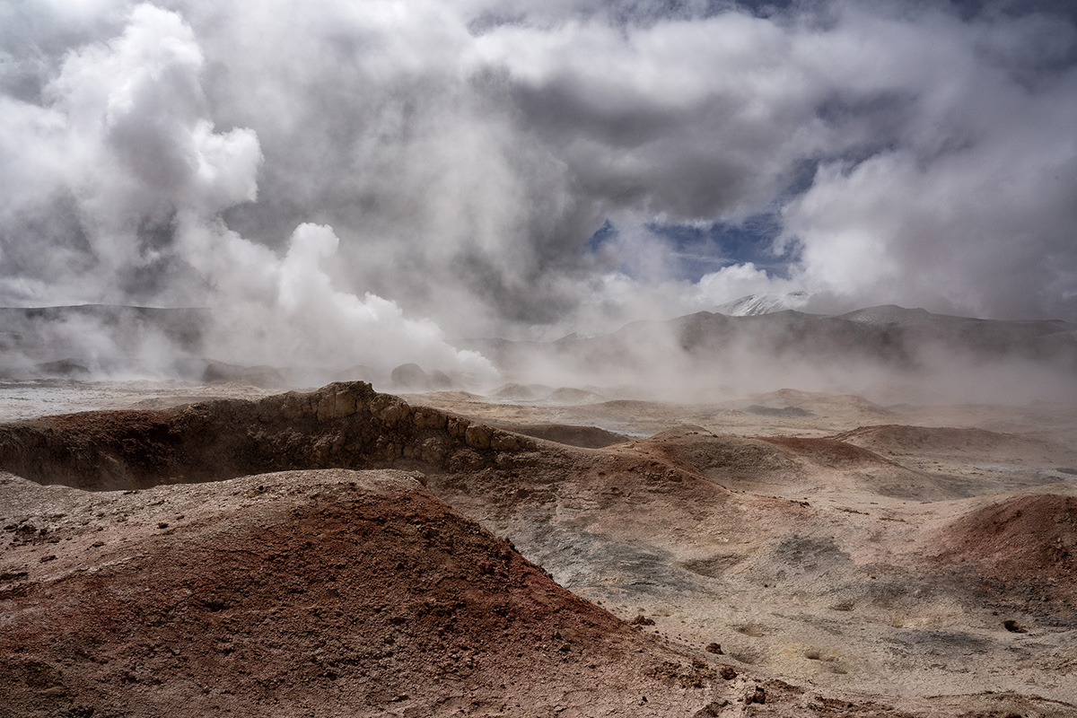
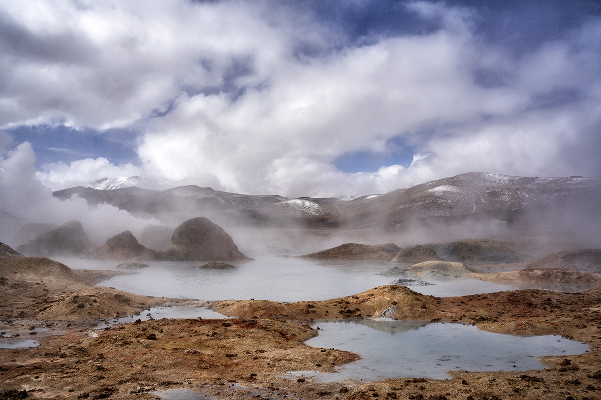
Sol de Menena: While driving through high plains, rocky out-crops and of course one of the largest salt flats in the world, we wondered if there was any more to this country that could visually stun us? It only took a somewhat short drive to realize, this trip was going to be nothing but continuous amazement. We entered the Sur Lipez Province and the area known as Rising Sun, Sol de Menena. A 10 square kilometer geothermal area with intense volcanic activity. With geysers, mud pots and fumaroles steam rising high into the sky, it seemed as if you were walking into prehistoric times. Without any official marked trails you can walk amazingly close to each feature. We also soon found out by the intense breathing we were both doing we were now at the highest altitude to date, just about 16,000 feet. For traveling reference, morning is supposed to be one of the best times for the most and highest steam emissions which create a much more dramatic image.

28-75mm Di III RXD: 1/320th Sec, f/22, ISO 100 @ 36mm
Click image to view larger

28-75mm Di III RXD: 1/400 Sec, f/18, ISO 100 @ 39mm
Click image to view larger
Salvador Dali Desert: We thought we may have been dreaming or even possibly hallucinating from lack of oxygen when our guide told us our next stop was going to be Salvador Dali Desert. Really in Bolivia, why Salvador Dali? When you drive through this barren high desert plain you soon realize that the random rock formations, calming tan hills and intense blue colored sky with bright high clouds create a very surreal landscape, resembling one of the artist paintings. The ever-changing highlights and shadows on the landscape as the clouds slowly moved overhead seemed to make the hills, volcanoes and rocks move mysteriously through the scene. Whatever it was this spot was both calming but slightly unnerving… incredibly beautiful though.
8 Images with 28-75mm Di III RXD: 1/400 Sec, f/16, ISO 100 @ 52mm
Click image to view larger
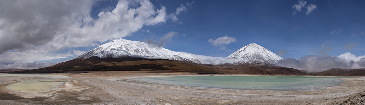
Laguna Verde: Finally, after a whirlwind 48 hours we come to our final stop, Laguna Verde. This very unique salt-lake that sits very close to the border of Chile contains many minerals including sulfur, lead, arsenic and calcium allowing it to stay unfrozen in temperatures well below zero. This also means that it is unsuitable for most forms of wildlife. What makes this lake very photographic is that it sits at the base of the Volcano Licancabur, which is almost perfectly cone shaped. It also sits within an endorheic basin, which means all waters converge into it and there are no natural drainage points into river or seas like most lakes have. This spot was the perfect final place to sit and take in all that we had seen during this visually stunning trip. The temperatures were warm and a slight breeze moved the clouds slowly across the sky as I remembered back to the past two days and all I had seen and how fortunate I was to have this amazing experience.
Lenses Used
SP 24-70mm F/2.8 Di VC USD G2
SP 70-200mm F/2.8 Di VC USD G2
28-75mm F/2.8 Di III RXD for Sony
More Photo Tips | Watch Videos | Learn More About Tamron Lenses | Photo Gallery